GEOTECHNICALENGINEERING1
ADELAIDE
HomeLaboratoryGrain size analysis (sieve + hydrometer)

Grain Size Analysis Laboratory in Adelaide: Sieve and Hydrometer Testing

Site investigations you can build on.

LEARN MORE

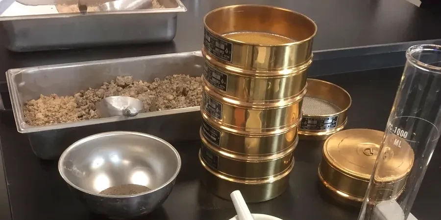
Adelaide, a city of approximately 1.4 million people laid out between the Mount Lofty Ranges and the Gulf St Vincent, sits atop an intricate patchwork of Quaternary alluvial sediments, deeply weathered Proterozoic basement, and the infamous Keswick Clay. These geological contrasts mean that a single construction site can transition from sandy loam to highly plastic clay within meters, making grain size analysis with both sieve and hydrometer methods a non-negotiable step in any rigorous geotechnical investigation. The low annual rainfall of around 540 mm and hot, dry summers demand precise soil classification to avoid issues with expansive behavior and poor drainage later on. In our experience managing projects across the Adelaide Plains, combining a standard SPT drilling program with a detailed grain size assessment is the only reliable way to determine the true engineering properties of these heterogeneous deposits before foundation design begins.

The hydrometer analysis doesn't just measure clay content — it reveals the mineralogical fingerprint of the soil, a key to predicting its shrink-swell potential in Adelaide's dry climate.

Our service areas

How we work

The semi-arid Mediterranean climate of Adelaide, with its long dry spells punctuated by intense winter rainfall, creates soils that can be surprisingly difficult to characterize without a full hydrometer analysis. Fine-grained materials derived from the weathering of the Adelaide Geosyncline rocks often contain a significant silt fraction that sieves alone cannot quantify. Our laboratory procedure follows AS 1726 guidelines meticulously, starting with mechanical sieving down to the 75-micron threshold and then transitioning to a sedimentation-based hydrometer test for the silt and clay fraction. This dual approach is critical for assessing the drainage potential of subgrades in the northern suburbs, where we frequently correlate results with in-situ permeability testing to design effective stormwater management systems. For pavement engineers working on infrastructure like the North-South Corridor, understanding the exact particle size distribution helps predict the performance of flexible pavements under Adelaide's cyclic wet-dry conditions, often informing decisions to stabilize the subgrade with lime in areas dominated by reactive clays.
Grain Size Analysis Laboratory in Adelaide: Sieve and Hydrometer Testing
Technical reference — Adelaide

Local geotechnical context

A residential development in the foothills near Belair recently encountered significant delays when the initial site classification, based solely on a visual-tactile assessment, failed to identify a deep lens of silty clay. The material was incorrectly assumed to be a well-graded gravel, leading to footing designs that experienced differential settlement after the first winter rains. A complete grain size analysis with hydrometer, had it been performed early, would have quantified the 35% silt content in that lens and triggered a reassessment of the bearing capacity. This scenario is common in the Adelaide Hills where colluvial deposits mix coarse and fine fractions unpredictably. Without accurate particle size data, the risk of misclassifying a soil as a low-plasticity silt instead of an elastic clay can lead to inadequate retaining wall designs, which is why we often integrate these lab results with retaining wall design parameters to ensure long-term structural stability.

Need a geotechnical assessment?

Reply within 24h.

Email: contact@geotechnicalengineering1.co

Relevant standards

AS 1726-2017: Geotechnical site investigations, AS 1289.3.6.1-2009: Particle size distribution – Standard method of analysis by sieving, AS 1289.3.6.3-2003: Particle size distribution – Standard method of fine analysis using a hydrometer, AS 4678-2002: Earth-retaining structures (for material classification context)

Typical values

ParameterTypical value
Test MethodAS 1726 (combined sieve and hydrometer)
Sieve Range75 mm down to 75 microns
Hydrometer TypeASTM 152H, calibrated at 20 °C
Dispersing AgentSodium hexametaphosphate solution
Minimum Sample Mass150 g for fine-grained soils
Reporting StandardUnified Soil Classification System (USCS) per AS 1726
Typical Turnaround3-5 business days from sample receipt

Quick answers

Why is a hydrometer test necessary when a sieve analysis already shows the soil is mostly sand?

In Adelaide's alluvial deposits, a soil that appears to be clean sand on a sieve stack often contains 5-15% silt and clay that can drastically alter its engineering behavior. This small percentage of fines reduces permeability significantly and can make the material frost-susceptible or prone to capillary rise. The hydrometer test quantifies this fraction precisely, which is critical for drainage design and for confirming whether the material meets the 'clean sand' criteria for compaction specifications.

How much does a combined grain size analysis cost for a single sample?

For a standard combined sieve and hydrometer analysis on a single soil sample, you can expect a laboratory fee in the range of AU$170 to AU$290, depending on the complexity of the material and the number of sieve sizes required. A quote is always provided upfront after we review the sample condition and the specific reporting format needed for your project.

What is the typical sample size needed for an accurate grain size distribution test?

The required sample mass depends on the maximum particle size. For soils with gravel up to 20 mm, we typically need about 2-3 kg of material. For fine-grained soils destined for hydrometer analysis, a 500-gram representative sample is usually sufficient, provided it is properly sealed in a plastic bag to preserve its natural moisture content. Our lab can advise on the exact quantity once we know the material type.

Location and service area

We serve projects in Adelaide and surrounding areas.

View larger map