GEOTECHNICALENGINEERING1
ADELAIDE
HomeGeophysicsElectrical resistivity / VES (Vertical Electrical Sounding)

Electrical Resistivity Testing (VES) Across Adelaide's Complex Subsurface

Site investigations you can build on.

LEARN MORE

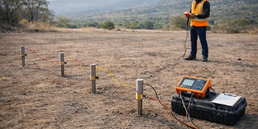
Adelaide's subsurface tells two very different stories. The western suburbs sit on Quaternary alluvium and estuarine clays, while the eastern foothills rise into fractured Proterozoic basement rock of the Mount Lofty Ranges. This sharp geological contrast creates a practical problem for site investigation: drilling alone often misses what lies between boreholes. Electrical resistivity testing (VES) fills that gap. It maps vertical changes in apparent resistivity, distinguishing saturated clay from dry sand, or weathered rock from competent stone. In a city where saline groundwater intrudes up to 5 km inland from Gulf St Vincent, resistivity becomes more than a profiling tool. It becomes a necessity. The method works by injecting a known current through stainless steel electrodes and measuring the resulting potential difference, building a 1D sounding curve that geophysicists invert to true resistivity versus depth. When combined with CPT soundings to calibrate the resistivity-to-soil-type correlation, the result is a continuous stratigraphic model that no number of boreholes alone could produce.

A VES sounding curve can tell you where saline water ends and fresh rock begins, without ever breaking ground.

Our service areas

How we work

The Quaternary sediments underlying Adelaide's CBD and western suburbs present a resistivity range from 0.5 ohm-m in hypersaline clay to over 100 ohm-m in dry, dense sands. This contrast is what makes VES so effective. Schlumberger array geometry is standard for vertical soundings, with AB/2 spacing expanding from 1.5 m to 150 m, reaching investigation depths of roughly 30 to 50 metres. In the foothills, where weathered siltstone grades into fresh rock, the resistivity jumps from 20–40 ohm-m to values exceeding 200 ohm-m. That transition depth is critical for footing design and basement excavation planning. Each VES station is georeferenced with RTK GPS and later correlated with borehole logs. For sites near the River Torrens, seasonal water table shifts alter bulk resistivity by 30% or more. The team schedules repeat surveys in both dry and wet seasons when foundation design requires it. Data inversion uses a least-squares smoothness-constrained algorithm. The output is a layered resistivity model with RMS error typically below 5%.
Electrical Resistivity Testing (VES) Across Adelaide's Complex Subsurface
Technical reference — Adelaide

Local geotechnical context

A site in Hindmarsh on alluvial clay and a site in Burnside on weathered phyllite could not be more different. In Hindmarsh, low resistivity (1–3 ohm-m) indicates saline, compressible clays that will settle under load. In Burnside, moderately high resistivity (40–80 ohm-m) over shallow bedrock suggests good bearing but also a risk of perched groundwater in the weathered zone. Missing either condition leads to costly redesign. On one project near Port Adelaide, a VES survey identified a buried paleochannel filled with soft organic silt that conventional boreholes had missed. The resistivity anomaly spanned only 12 metres laterally. Without it, differential settlement would have cracked the slab within two years. The same principle applies when assessing groundwater salinity for concrete durability. Resistivity below 5 ohm-m flags a potentially aggressive exposure class that demands sulfate-resisting cement.

Need a geotechnical assessment?

Reply within 24h.

Email: contact@geotechnicalengineering1.co

Relevant standards

AS 1726:2017 (Geotechnical site investigations), AS 1289 (DC resistivity for subsurface investigation), AS/NZS 1170.2:2021 (Structural design actions – wind), AS 3600:2018 (Concrete structures – durability requirements)

Typical values

ParameterTypical value
Electrode arraySchlumberger (standard), Wenner optional
Max AB/2 spacing150 m (30–50 m investigation depth)
Current injectionDC, 12V battery with 250W transmitter
Apparent resistivity range0.2 to 10,000 ohm-m
Inversion methodLeast-squares smoothness-constrained (RES2DINV)
Result output1D layered model, true resistivity vs depth
PositioningRTK GPS (±2 cm horizontal)

Quick answers

What depth can a VES survey reach in Adelaide soils?

With a maximum AB/2 spacing of 150 metres, the investigation depth typically ranges from 30 to 50 metres. Actual penetration depends on the resistivity of near-surface layers. In conductive clays of the western suburbs, depth is slightly reduced compared to the resistive sands of the eastern plains.

How much does an electrical resistivity sounding cost?

A single VES station with full inversion and reporting falls between AU$880 and AU$1,520. The final cost depends on electrode spacing, terrain access, and whether the survey forms part of a larger geophysical package.

Can VES distinguish between saline clay and clean sand?

Yes, and this is one of its most practical applications. Saline clay exhibits resistivity below 3 ohm-m, while clean sand above the water table often reads above 50 ohm-m. The contrast is unambiguous when calibrated with at least one borehole or CPT log.

Is VES better than seismic refraction for bedrock depth?

They complement each other. VES responds to porosity and pore-fluid salinity, while seismic refraction responds to elastic stiffness. In the Mount Lofty Ranges, where weathered rock transitions gradually to fresh, VES often resolves the weathering front more clearly than refraction.

Location and service area

We serve projects in Adelaide and surrounding areas.

View larger map